I’ve always been crazy about old pathways (and apparently I’m not alone) as they are filled with romance and mystique. I love to scrutinize where a road begins, or sadly, where it finishes its vital course. Route 66 played an enormous part in the history of American highways and much has been written about “The Mother Road.”
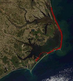
 Two of my favorite personal reminisces are of Highway 12 on the Outer Banks. Parts of it are forever washing away and as the landscape plays hide and seek with the encroaching sand, the vista changes with each passing storm. Abrupt curves in the otherwise straight road tell the tale of the constant fight to keep the highway one step ahead of the hungry ocean. The bends are the result of rerouting the road after erosion and storms gobbled up dunes and pavement.
North Carolina Highway 12, which provides access to the Outer Banks and connects its communities, is another line in the sand. The state has spent tens of millions of dollars rebuilding, relocating and trying to protect the highway only to have sections of it continually washed away by the sea. Critics say it is an exercise in futility and a waste of state and federal tax dollars. To some, Highway 12 is a symbol, not only of the problem on the Outer Banks, but on most of the state’s barrier islands.
I also fondly remember the eastward development of Highway 64 back when the extension only got as far as east of Rocky Mount. As the years past, it morphed from a sleepy two-lane ribbon of pavement winding through every small town to a bustling four-lane bypass marching toward the welcoming beach.
It is only proper and fitting that I remain completely fascinated with these most famous stretches of ancient construction…
Hadrian's Wall (Latin: Vallum Hadriani) was a stone and turf fortification built by the Roman Empire across the width of Great Britain to prevent military raids by the tribes of Scotland to the north, to improve economic stability and provide peaceful conditions in the Roman province of Britannia to the south, to physically mark the frontier of the Empire, and to separate the unruly Selgovae tribe in the north from the Brigantes in the south and discourage them from uniting. The wall was the northern border of the Empire in Britain for much of the Roman Empire's rule, and also the most heavily fortified border in the Empire. In addition to its use as a military fortification, it is thought that the gates through the wall would also have served as customs posts to allow trade taxation.
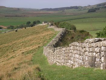 Sections of Hadrian's Wall remain near Greenhead and along the route, though other large sections have been dismantled over the years to use the stones for various nearby construction projects.
Hadrian's Wall was 80 Roman miles long, its width and height dependent on the construction materials which were available nearby. It extended from the west from Wallsend on the River Tyne to the shore of the Solway Firth. TheA69 and B6318 roads follow the course of the wall as it starts in Newcastle upon Tyne to Carlisle, then on round the northern coast of Cumbria. The Wall is entirely in England and south of the border with Scotland by 15 kilometres (9 mi) in the west and 110 kilometres (68 mi) in the east.
In the months after Hadrian's death in 138, the new emperor, essentially abandoned the wall, though leaving it occupied in a support role, and began building a new wall in Scotland proper, about 160 kilometres (100 mi) north, the Antonine Wall. Antonine was unable to conquer the northern tribes and so when Marcus Aurelius became emperor, he abandoned the Antonine Wall and occupied Hadrian's Wall once again in 164. It remained occupied by Roman troops until their withdrawal from Britain. In the late 4th century, barbarian invasions, economic decline, and military coups loosened the Empire's hold on Britain. By 410, the Roman administration and its legions were gone, and Britain was left to look to its own defenses and government. The garrisons, by now probably made up mostly of local Britons who had nowhere else to go, probably lingered on in some form for generations. Archaeology is beginning to reveal that some parts of the Wall remained occupied well into the 5th century. But in time the wall was abandoned and fell into ruin. Over the centuries a large proportion of the stone was reused in other local building which continued until the 20th century. A significant portion of the wall still exists, particularly the mid-section, and for much of its length the wall can be followed on foot.
Appian Way
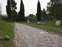 In ancient times, Roman roads were considered monuments. Over a period of centuries, the Romans built an efficient network that ultimately stretched for over 50,000 miles in an area than now belongs to more than 30 countries. The first important via publica, or highway as it would be called today, was the Via Appia, or Appian Way. Known as the queen of roads, it linked Rome with Brundisium, the port city that was the gateway to the East. This road took its name from Appius Claudius Caecus, the Roman official who started building it about 312 B.C.E.
 Roman roads were carefully designed and were built to be solid, useful, and beautiful, with a destination by means of the shortest possible route, which explains why many have long straight stretches. Often, though, the roads had to follow the natural contours of the terrain. Where possible, in hilly and mountainous areas, Roman engineers built their roads halfway up the slopes, along the sunny side of the mountain. For road users, this position minimized any inconvenience that might be caused by adverse weather conditions. Roman roads, then, have proved to be extraordinary and lasting monuments that one may still view today.
And who can forget that mythical trail from childhood, the glorious Yellow Brick Road? Whatever the goal, it’s about the journey, not necessarily the destination. Here’s to wanderlust and adventure!! ;)
3 comments:
Whatever the goal, it’s about the journey, not necessarily the destination. Here’s to wanderlust and adventure!!
Amen!
I personally LOVE 12 & 66: they are amazing!
I love roads. They fill me with wonder and wonderlust
Have never been to the Outer Hanks but have always wanted to
Our beaches are victims of erosion but since they're the Hamptons they become a national joke
It is serious because Long Island needs barrier islands to exist
And I will always always follow the Yellow Brick Road. They did find their way home eventually :-)
TC--yes, there is nothing like the Road that leads to Endless Possibilities. :)
Pia--the Outer Banks are truly my favorite and I talk about them occasionally on here. I do have a pic of me standing on part of Hwy 12 that had been abandoned when they rebuilt it further inland and when I scan it I just might post it. Thanks for your comment.
:)
I too will always take the Yellow Brick Road...
Post a Comment